Ocean Ecosystem and Resources : Characterizing the Mid-Atlantic Ocean Ecosystem
Oceanographic Setting and Processes
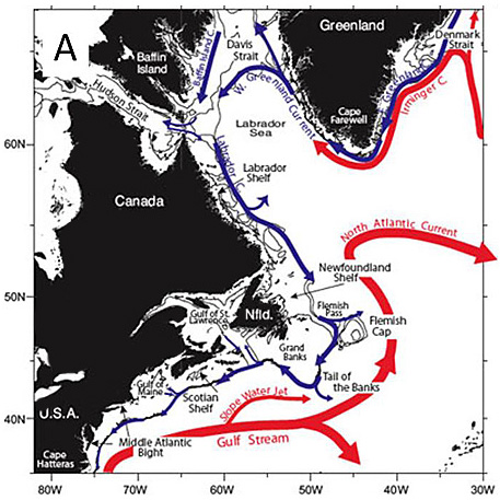
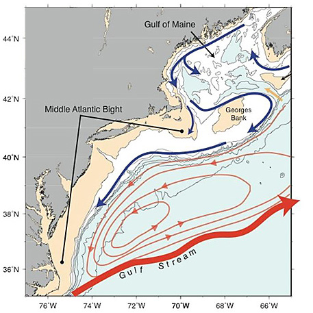
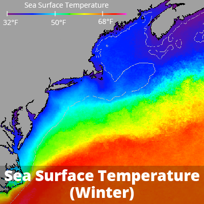
The Mid-Atlantic ocean is influenced by cool waters flowing southward from New England and by the warm waters of the Gulf Stream, which flows northward along the coast from Florida to North Carolina before heading northeasterly offshore of the Mid-Atlantic states (Stevenson et al. 2004). The Gulf Stream exerts important influences on the ecosystem and is an important migratory corridor for many marine species, including marine mammals, sea turtles, and fish (NEFSC 2015).
Map of the western North Atlantic Ocean showing two dominant current systems affecting the Mid-Atlantic region: Gulf Stream (red) and Labrador Current (blue). (Credit: Fratantoni and Pickart, 2007)
Wintertime satellite imagery reveals cold water (blue) near the Mid-Atlantic coast. Warmer water (red) lies offshore in the Gulf Stream. (Credit: NOAA)
This map shows average annual range of sea surface temperature from 1985 to 2009 based on satellite imagery. The Mid-Atlantic coast experiences a wide range of temperatures, as indicated by red and orange. (Credit: NOAA)
Stratification
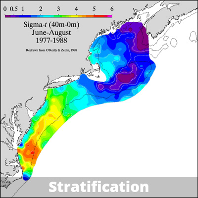
Seasonal warming and cooling in nearshore and shelf waters are important for ecosystem processes in the region (NEFSC 2015), as are pulses of freshwater from the Hudson Raritan Estuary System, Delaware Bay, and Chesapeake Bay that influence coastal and ocean salinity. In early June each year, the combination of warm water temperatures and high freshwater inputs leads to stratification of the water column, which often lasts until October (Stevenson et al. 2004). Stratification occurs when warm fresh water forms a layer over cooler saltier bottom water, acting as a barrier to water mixing.
Regional differences in summer stratification, showing strongly stratified areas (indicated by red, orange, and yellow colors) in the Mid-Atlantic Bight. (Credit: NOAA)
Frontal Zones
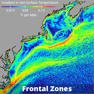
Frontal zones are boundaries where different water masses lie adjacent to each other, and water temperature, salinity, and other oceanographic characteristics change sharply over a short distance. Several factors can cause such boundaries. Some frontal zones arise where tidal forces converge, and they can be important feeding locations for fish, birds, and marine mammals because plankton become concentrated there. Another type of frontal zone develops between the cooler, fresher water over the continental shelf and the warmer, saltier water over the continental slope. The shelf-slope front tends to be an area where marine mammals and the top fish predators concentrate in search of prey (NEFSC 2015).
Red and yellow indicate frontal zones including the dominant front at the edge of the continental shelf, as well as nearshore tidal mixing fronts. (Credit: NOAA)

